In July 2017, the Virginia Department of Transportation (VDOT) adopted a new policy for arterial roadways that was designed to preserve and enhance the capacity and safety of critical transportation links that are not included in the Interstate Highway System. These roadways accommodate long-distance mobility of people and goods throughout the Commonwealth and are generally located in areas that do not have access to a parallel interstate route. The Arterial Preservation Program places an emphasis on the following:
• Providing mainline through traffic on arterial roadways with priority over side streets, land access, commercial entrances, and private/local use.
• Preserving the travel speed/capacity of through traffic by strategically limiting access points (i.e., other roadways and entrances) and traffic control devices.
• Prioritizing safety through alternative intersection designs that limit conflict points.
The roadway segments, broadly categorized as inside or outside urban areas (with urban areas being designated as having a population of 50,000 or more), selected for the Arterial Preservation Program are categorized under the following types:
• Mobility Preservation Segments (MPS) are arterial roadways outside urban areas that serve long-distance mobility needs where no parallel interstate route exists. The focus of MPS is preserving mobility through the minimization of mainline delays whenever access changes are proposed.
• Mobility Enhancement Segments (MES) are arterial roadways inside urban areas where there may be opportunities to improve traffic flow without major roadway widening. Significant traffic growth and travel delays often occur on segments due to the impacts of commercial entrances and traffic signals that serve adjacent land uses. The MES are directed to incorporate travel accommodations for all modes of transportation, including bicycle and pedestrian, similar to a Complete Streets concept.
Implementation strategies to attain preservation and enhancement of arterial corridors include:
• Improving access management
• Comprehensive transportation and zoning planning efforts
• Eliminating unwarranted traffic signals
• Implementing innovative intersection configurations
• Providing infrastructure for all modes of transportation
A statewide map showing all segments in the mobility preservation and mobility enhancement arterial programs can be found here.
The VDOT webpage that outlines the Arterial Preservation Program can be accessed here. http://www.virginiadot.org/programs/vdot_arterial_preservation_program.asp
What does Arterial Preservation mean?
The overarching goal of the Arterial Preservation Program is to preserve mobility along identified arterial corridors. As an alternative to widening major highways, preservation and enhancement strategies promote the use of innovative transportation solutions, to (1) add roadway capacity, (2) minimize through traffic delays, and (3) improve safety, while considering local economic development needs.
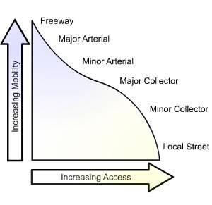
Figure 1 illustrates the fluid nature of balancing mobility versus access. Access management addresses the programmatic control of location, spacing, design, and operation of entrances, median crossovers, interchanges, and street connections to an arterial roadway. As mobility and speed are prioritized, access points are removed, bypassed, or minimized. From a traffic engineering standpoint, access control provides a reduction in conflict points and a reduction of locations where high-speed traffic is interacting with traffic entering/exiting a roadway.
In short, the primary function of the arterial preservation effort is serving long distance travelers and goods movements; the road’s ability to perform this function safely and efficiently must be preserved and is given priority over local access.
How does Arterial Preservation impact development?
VDOT’s policy guidelines are applicable to the proposed construction of any new access points or the improvement of existing access points and intersections within a corridor identified in the Arterial Preservation Program. This includes proposed access points for public and private land development, as well as new roadways. VDOT is focused on enhancing current policies and encouraging the use of innovative design strategies to preserve capacity, increase mobility for all modes of transportation, and prioritize safety. As part of the program, VDOT initiated an agency-wide review of all project development processes to determine how to implement the new policy.
Any planned development on an identified arterial will be required to follow new procedures regarding:
• Road Design Manual
o All new crossovers and traffic signals will require approval by both the VDOT District Administrator and the VDOT State Location & Design Engineer
o Innovative intersection designs and roundabouts will be considered at all proposed access points
• Land Use
o Changes to requesting waivers/exceptions involving potential signalized intersections
o Regardless of whether a proposed crossover is subject to an access management exception, final approval of new crossovers must be reviewed by the VDOT District Administrator and the VDOT State Location & Design Engineer
• Traffic Engineering
o Signal justification reports (SJR) are required, in addition to traffic signal warrant analyses where applicable, which require the consideration/evaluation of innovative intersection/interchange alternatives
• Transportation and Mobility Planning Division
o Changes to the process for conducting short- and long-range planning studies on the Arterial Preservation and Enhancement networks
Primarily, the goal of the arterial preservation policy is that all “planned improvements shall minimize delay for through traffic without compromising the safety for local drivers and other road users.” The policy requires that all existing and future access points be planned to minimize delay for through traffic. In short, the policy aims to prioritize long-distance traffic travelling through less developed areas over local traffic. Local traffic, which intimately drives the local economy, is vitally important to ensure the long-term success of underdeveloped areas and should not be bypassed from larger regional networks.
Arterial preservation limits development potential for localities by restricting access, with more emphasis placed on relieving delays on long-distance through traffic. Subsequently, the policy has the potential to shift VDOT from an advisory role to an authority role regarding local land use decisions and access for local economic development. If a local government determines that more access is best for the economic development of an area, VDOT can overrule the improvement of local access (and therefore economic development) in favor of statewide mobility goals.
Further, another goal of the program aims to remove existing traffic signals along identified corridors and limit new signals and median crossovers. The program will ensure that more grade-separated and alternative intersection concepts are implemented over traditional intersection designs. It should be noted that alternative intersection solutions can provide safety benefits and improved mobility over traditional intersection options when implemented appropriately. VDOT intends for these new policies to aide localities in making long-range land use decisions and help plan for future growth and economic development.
The development of any potential access point or intersection must consider the following process, in the specified order, for improvement options:
1. Roundabout
2. Unsignalized Alternative Intersection Design (RCUT Super Street Concept, etc.)
3. Signalized Alternative Intersection Design (Continuous Green-T, etc.)
4. Traditional Intersection
Under the new policy, there is an increased amount of traffic engineering study and preliminary engineering design required in order to determine whether a traditional (signalized) intersection design is the best option along an existing corridor. The arterial preservation program is anticipated to increase design costs, construction costs, and right-of-way costs due to the larger footprint of many alternative intersection and interchange designs, relative to a traditional intersection.
The Arterial Enhancement Program introduces requirements to provide access and mobility for all transportation modes, including bicycles and pedestrians, by introducing a “Complete Streets” concept. Complete Streets are corridors designed and operated to enable safe access for all users of all ages and abilities. The policy requires any planned development along an enhancement corridor to adhere to access management guidelines and anticipate additional right-of-way needs to accommodate pedestrian/bicycle facilities. The right-of-way necessary to install improvements to comply with the Complete Streets concept will impact established corridors more harshly.
Final Thoughts
With expected changes in demographics, technology, and mode choice, are major infrastructure improvements necessary in rural areas to address growth issues that may never occur? With limited funding for localities available via SMART SCALE, Revenue Sharing, and Economic Development Access programs, should projects be pursued that have limited benefit to the localities?
To reduce impacts of the policy, local economic development may avoid major corridors and seek out less developed areas, potentially with inadequate infrastructure. How will the policy be applied to localities that do not have any routes located on the Arterial Preservation network? Will major economic development projects seek out property away from these arterial corridors, thereby giving an upper hand to localities and areas that do not have the same restrictions?
The Arterial Preservation Program is intended to protect taxpayer investments. If a locality chooses local access over through traffic in order to stimulate local economic activity, who determines what is best for that community?