Overview
Timmons Group developed the Community Assessor web and mobile application for the Texas A&M Forest Service (TFS) to support community risk assessments throughout the Texas. The web and mobile applications will be used by TFS Wildland Urban Interface (WUI) coordinators and local fire departments to set up assessment projects for Cities and Counties, delineate community boundaries within a project jurisdiction, assign team members to projects, conduct wildfire risk assessments for those communities while out in the field, and then produce data and reports to be used for developing Community Wildfire Protection Plans (CWPPs). The Community Assessor application is part of the Texas Wildfire Risk Assessment Portal (TxWRAP).
The Problem:
The Healthy Forests Restoration Act (HFRA) provided communities with a tremendous opportunity to influence where and how federal agencies implement fuel reduction projects on federal lands. A Community Wildfire Protection Plan (CWPP) is the most effective way to take advantage of this opportunity. Additionally, communities with Community Wildfire Protection Plans in place will be given priority for funding of hazardous fuels reduction projects carried out under the auspices of the HFRA. TFS is a collaborator with counties and municipalities in Texas and supports and maintains their CWPP development. TFS has historically had a manual process to plan, coordinate, conduct, and work with local fire departments and homeowners associations. This included paper-based community assessment forms, non-digital tracking of community boundaries, and limited consistency in the recommendations provided to localities for their CWPP development.
Our Solution:
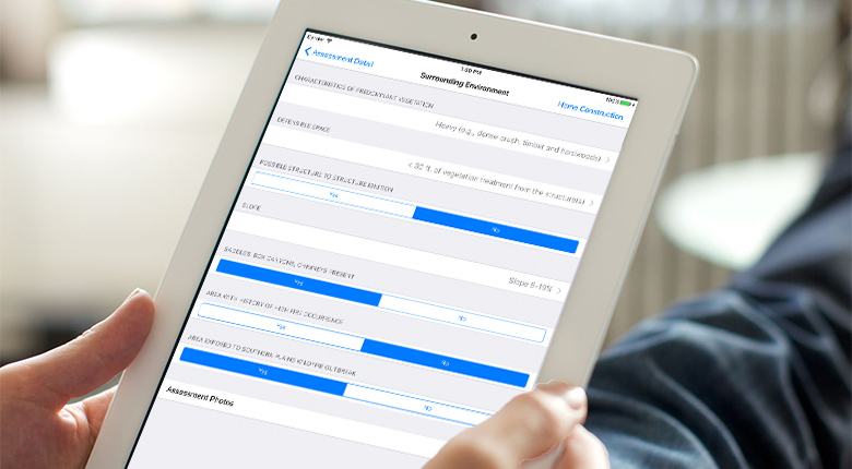
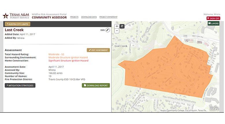
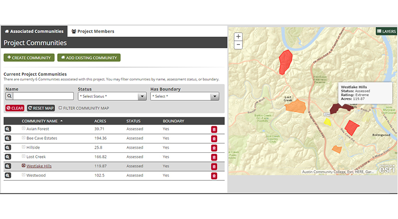
Timmons Group developed a role-based web-based application to help TFS and local fire departments sketch out WUI community boundaries on a map, and enable assigned project team members to search, download data and run reports for communities throughout the Texas. A native iOS mobile application was developed so that field assessors can easily navigate to and enter wildfire risk assessments for pre-mapped communities while onsite. If during a field visit the assessor finds a new community that needs to be assessed, they simply create an ad-hoc community and can proceed with an assessment for that community. The mobile application also allows assessors to work in on-line or off-line modes, so that connectivity issues do not prevent data entry. The Community Assessor web application allows users to download the Single Community Assessment Report as well as a CWPP Report that details all communities for the Project, including a map and table with the total hazard rating for each community. Finally, a map layer that shows all of the assessed communities symbolized by total hazard rating is available for users of the TxWRAP Public and Professional Viewers.