Overview
The North Carolina Department of Transportation (NCDOT) is a leader in the transportation industry, consistently implementing innovative solutions and driving change to meet operational needs. NCDOT contracted with Timmons Group to update and improve SPOT Online, their statewide project prioritization tool.
SPOT Online has modernized the NCDOT Strategic Prioritization Office of Transportation (SPOT) project prioritization evaluation and decision support process by providing end users with a web based geospatial and analytical data entry and evaluation tool. SPOT Online uses a systematic data-driven process for prioritizing major transportation projects in the state and making investment decisions. Projects are evaluated based on their merit through an analysis of the existing and future conditions, the benefits the project is expected to provide, the project’s multi-modal characteristics and how the project fits in with local priorities. It provides immediate feedback of project data entry accuracy and project scoring based on defined project evaluation parameters. The outcome of the Strategic Prioritization Process serves as input to the Draft State Transportation Improvement Program (STIP).
Key SPOT Online capabilities include:
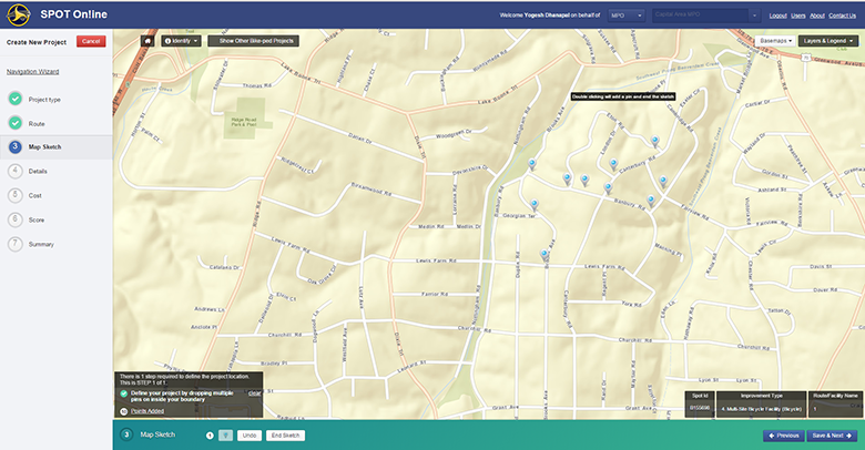
- The ability to define a project area by points, lines, and/or polygons.
- This enables users to easily locate proposed projects and associated improvements using a combination of existing infrastructure and proposed improvements, without being a GIS expert.
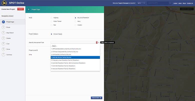
- The ability to accommodate multi-modal transportation improvements (e.g. highway, ferry, rail, public transportation, bicycle & pedestrian, and aviation) within the same project. Each mode having its own unique analytical parameters.
- Integration of robust analytical geoprocessing functions in a process driven workflow for accurately calculating factors that affected the scoring such as:
- Average traffic volumes and capacities
- Distance to nearest multimodal/freight terminals
- Number of past crashes and incidents within a specified buffer of the proposed project
- Determining the funding region based on the percentage length overlay in each division
- Incorporation of complex business rules so that the proposed improvement complies with the existing infrastructure
- This prevents the user from converting a 6 lane interstate to a 2 lane roadway
David Wasserman, NCDOT SPOT business owner comments, “Matt McCracken and his team at Timmons Group did an outstanding job at updating SPOT Online for the 4th Generation of the Strategic Prioritization Process. The work was done under an exceptionally tight timeframe, but the team was in constant coordination with the NCDOT project team to ensure an on-time delivery of the completed project. We’re very pleased with the end result and the successful implementation of SPOT Online for P4.0.”
Technology Stack
- ArcGIS JavaScript API 3.7 for all mapping components
- Pure Dojo AMD pattern of coding for the frontend
- Extensive use of Bootstrap for styling
- Geoprocessing functionalities using Python
- WCF REST Service for managing all backend services
- ArcObjects for certain spatial data download components in the web application
- ArcGIS Server 10.3 for hosting all Map, GP, geometry and feature services
- ArcGIS Desktop 10.3 for creating and publishing all Map, GP and Feature services
For additional information on the Strategic Prioritization Process, including project data and scores, please click here.